Badger

Badger

Iron Bark II

Iron Bark II

About Me

My photo
I first crossed the Atlantic in 1975 on 'Stormalong', a 28ft Wharram-designed catamaran. Back in the UK, Pete and I bought an ex 6-metre racing yacht, 'Sheila', living on her for 4 years. Wanting to do more and go further, we built 'Badger' - the best boat in the world - sailing her 110,000 miles, to the Arctic and the Antarctic, around the Atlantic North and South and into the Baltic. She had junk rig - the only rig I will ever now cruise with. Pete wanted to build a 38 ft junk-rigged catamaran, 'China Moon' - which he designed. But before the project was finished, we went our separate ways. A year later I joined Trevor Robertson aboard his 35ft 'Iron Bark'. We explored the Canadian Maritimes, crossed the Atlantic twice, wintered in Greenland and crossed the Pacific to Australia and New Zealand. I fell in love with NZ and jumping ship, bought my own boat while Trevor carried on voyaging. I put a junk rig onto ‘Fantail’ and, having decided that N Island offered better cruising opportunities than S Island, sailed up there in 2012. Looking for a boat to see me out, I built the 26ft 'FanShi' and now live on board her, pottering about, generally around the Bay of Islands.

Wednesday, 17 July 2024

HARCOURT ISLAND AND PASSAGE


54o30'S 36o00'W
Chart 3597, South Georgia


A narrow strait separates Harcourt Island from the coast and in reasonable weather forms a shortcut inside Harcourt Island to and from Royal Bay. It is possible to anchor in this, off the island in a small pool.

The pool is approximately 50m across and a vessel will need to moor or to take lines ashore to keep near its centre. The depth is 4m and it is clear of kelp. The channel runs N-S and the anchorage is open to the sea from these directions, but is otherwise sheltered. When visited, there were a few pieces of ice on the beach on Harcourt Island.

The accompanying sketch chart and photographs show the channel and anchorage. This passage is probably best avoided in strong winds and/or a large swell. Harcourt Island seemed to be out of the line of the W wind blowing in Royal Bay.


ST ANDREW'S BAY


54o25'S 36o10'W
Chart 3597, South Georgia

The shelter offered by the headland at the N end of the beach is better than it appears on the chart and provides protection from the sea from S through W and N to NE. Tuck well into the northern corner and anchor in about 5.5m. No kelp.

A very large King Penguin colony is situated at the moraine close behind the beach. In clear weather, with Mount Paget and the other peaks for a backdrop, it is a spectacular sight and a popular place for visiting wildlife camera crews.


To visit the penguin colony it is easiest to land S of the glacier stream, if the swell permits. The stream runs very strongly and is usually at least 60cm deep. Several people have been knocked over by the force of the current. The landing at the N end of the beach is less subject to swell. Near the round bluff that projects from the headland, there is a narrow channel in the flat rocks where landing may be possible, even with a large surf on the beach.

On the N side of the moraine, several hundred metres from the beach is a BAS hut, now used as a refuge.
Even if there is too much swell to land so that one can visit the penguin colony, it is well worth a sail along the beach (6m depth quite close in) to view this spectacle.


ST ANDREW'S BAY, LOOKING S, CHANNEL BETWEEN FLAT ROCKS IN FOREGROUND


Sunday, 14 July 2024

OCEAN HARBOUR


54o20'S 36o16'W
Chart 3597, South Georgia

This well-protected harbour is the site of an old whaling station, that was closed down in 1920, when it was amalgamated with Stromness. Not much of the buildings remain, but there is a narrow-gauge steam locomotive, lying on its side to the N of the site   


and the wreck of the Bayard can be seen on the S shore. This iron-hulled vessel was built in Liverpool in 1864 and was wrecked in 1911, when she broke adrift from the coaling jetty (the remains of which can be seen on the N shore) in a severe gale, was driven ashore and holed.


The bay is open to the E, but apart from this, there is complete protection from the sea. The chart shows a rock, but we saw no sign of it and the scale is too small to identify its position accurately. Once past the bluff, at the S entrance to the harbour keep to the middle of the bay where there is less kelp.

The remains of a light structure can be seen on the bluff.


Anchor near the head of the bay in 5.5m. There is kelp about, but it is not very thick.


OCEAN HARBOUR, LOOKING NE


Friday, 12 July 2024

COBBLER COVE


54o16'S 36o18'W                                                                           
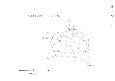
Chart 3589, Cobbler's Cove
 
 
A narrow entrance leads into this small cove, which offers complete shelter from the sea.  The land to the NW rises very steeply, which suggests that this may well be a bad place for katabatic winds in a NW gale.

The entrance is straightforward and by taking a sweep to the S, once past the narrows, most of the kelp is avoided. 

Anchor off the beach at the W end, in 6.5m, in a patch clear of kelp.

Cobbler's Cove is shown as Pleasant Harbour on old charts.  It is possibly named for white-chinned petrels that nested there: old-time sailors referred to them as 'shoemakers'.


COBBLERS COVE, LOOKING NE


GODTHUL

54o17'S 36o17'W                                                                                       Chart 3589, Godthul


Godthul was another harbour used by the whalers, but here there was a factory ship and the whales were flensed, while they were still floating, from Jolle boats.  Artifacts from these days can still be seen ashore; there are, for example, a couple of tanks, the remains of a shed, a heap of oak and steel barrels, three Jolle boats and several dinghies.  The beach is strewn with whale bones. 


The ruins are in the SE corner of the bay and, tucked in here, there is complete protection from the sea.  However, there is a 1 mile fetch with winds from the N or NW.  Anchor in a patch clear of kelp, off the shed, in about 6.5m.


GODTHUL, LOOKING NW


Monday, 21 November 2016

Harbours between Banks Peninsula and Stewart Island

Guy Garey from Dunedin, sent me the following, which would be very useful to people circumnavigating New Zealand this summer.  Or any other summer for that matter!

Going S from Banks Peninsula and its many harbours (the biggest being Akaroa - translated from Maori as 'Long Harbour'), you can count the decent havens on just a few fingers: Timaru (rather industrial), Oamaru (utterly not recommended unless you have excellent and up-to-date local knowledge), Dunedin, the Nuggets (a peninsula one can shelter behind), Waikawa (entrance as per Oamaru), perhaps Tautuku, and certainly Bluff . Bluff can have serious tides, as the entrance drains a large estuary. Call Mary on VHF channel 61 or 63 to get up to the minute recommendations. Hey, even (maybe even mostly) the fishermen check in. It is the smart thing to do. Once out of the shipping channels one can go lots of places to anchor, though with three metre (10 ft) tides (as I experienced) make sure you have clear water at low tide. 

Bluff is famous for  being both the furthest S one can go on 'mainland' NZ (which is actually Slope Pt, a few miles to the E) and for its seafood, especially its oysters. Blue cod, crayfish and paua (abalone near relative) are most often available, and the oysters during their own somewhat short season. If you like oysters and happen to be in Bluff when it is season, then don't be shy. All of NZ eagerly awaits the oyster season, and the smart eaters move fast. Bluff is also a good place to get repairs done, and avail one's self of safety gear (life raft, epirb, &c) because this is where the fishermen get theirs. 

If one goes S from Bluff, then Rakiura/Stewart Island is the next port of call. Get the latest Foveaux Strait conditions and weather from Fisherman's Radio before you cross the Strait, as conditions can change for the seriously worse almost instantly. One can also get flat calm conditions, as we did last time we went there. Even Cape Horn must have calms, one imagines. Stewart Island's waters are strewn with rocks; navigators pay attention! The nearest harbour/port/anchorage is Half Moon Bay, which sits before the settlement of Oban. Halfmoon Bay is protected from anything except a screaming NW'ly. Most things are available here, often not cheaply since transport is not inexpensive. In a small settlement such as Oban there are many 'the's', the foodstore, the pub, the wharf, &c. Yes, one can get lucky and tie up briefly to the wharf for taking on crew/passengers or water, but ask at the ferry dock first. At the 4 Square variety market one can obtain food, wine and beer (at surprisingly affordable prices) and other often-requested supplies. Both diesel and petrol and LPG are available at the petrol station. It seems that the only negatives are the prices... and the sandflies. The locals say that you get used to them (the flies), but I always return from Stewart Island with weeping bites where I scratched.  Distances around Oban are short, so you can walk from one end of the town to the other in an easy pace. Don't let that fool you though, because  Stewart Island is a big place; most of it in National Park. Close around the corner going E is Paterson Inlet, big enough to get rough conditions, but big enough also to have numerous nooks and crannies. I can recommend Kaipipi Bay (almost landlocked) for good shelter at the end of a narrow entrance and having nice, heavy mud. 

Dunedin has a wonderful harbour, the Otago Harbour, that it sits at the head of. The harbour offers excellent refuge from winds and seas of any direction, though getting through the narrow and somewhat winding entrance in a wind against tide situation can be a bit rough. The bays offering the best shelter are Portobello Bay (to the N of the hamlet of Portobello, which is on the S side of the Portobello peninsula), Latham Bay (directly at Portobello) and Broad Bay (still on the E side but another nautical mile further along).  

The trouble with the Otago Harbour is that it is tidal and shallow. At half to or after high water any boat with 2m or less should have no trouble at all... in the natural channels. Consult your chart and depth sounder fairly often, though if you do run aground most of the harbour is mud and sand so there is generally nothing more than pride affected. This is NOT the case with the main (W-side ship) channel which is lined with rocks, beginning on its E side where the middle ground cut/channel (from Kilgour Pt to Grassy Pt) is. 

Do remember that Dunedin is near enough to 46 degrees South latitude, hence it is often cold here. We do get warm and even hot temperatures, but Barbados it isn't. One nice thing about a higher latitude is the long light one may have before darkness. At summer's solstice one can still read the paper outside at 2200.

Dunedin was Aotearoa NZ's big city in the latter half of the 19th century, mainly due to the discovery of gold nearby in 1863 (+/-); and it remains an important center of urban life, supply and repair. The visitor's center in the Octagon (center of the city) is helpful for general & tourist information. For boat oriented things it would probably be a good idea to contact Read Marine (ph (03) 474 0871), who either have what you are looking for or can direct you in your search.