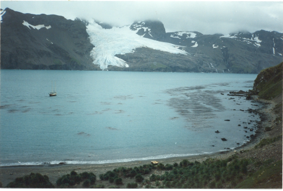
This coast is described in the Admiralty Pilot as being ‘little visited’, which is not surprising, because it is much wilder than are the N and E coasts. From Cape Nunez SE, there are few harbours and it is a lee shore to a SW gale. Added to this is the fact that the surveys of the area are not complete and rocks and reefs exist that are not marked on the chart. There is usually a big SW swell along the shore.
Showing posts with label South Georgia - south-west coast. Show all posts
Thursday, 13 February 2025
UNDINE HARBOUR
54º02'S
37º58'W
Chart
3585, Undine Harbour
The approach to Undine Harbour is not straightforward, with shoals, kelp banks and the odd rock extending eastward from the Birdie Rocks to Grassholm. Passing to the NW of Birdie Rocks or N of Grassholm will give the clearest approach, but care should be taken, as there are several uncharted rocks.
The entrance to Undine Harbour is easily
identified with the conspicuous, flat-topped O'Connor Island (49m)
marking the E side of the entrance.
We anchored in the NW corner in
6m, mud, off the conspicuous stream and outside the extensive kelp.
The harbour gives good protection from all but the S. When visited,
the shoals in Discovery Bay seemed to dampen down most of the swell
in the anchorage.
A short walk over the low land at the head of the
bay takes you to Elsehul.
UNDINE HARBOUR, LOOKING S
COAL HARBOUR
54°02'S
37°57'W
Chart
3585, Undine Harbour
This
is an attractive bay, ½ mile E of Undine Harbour. The entrance has
kelp extending all the way across, but this is thinner towards the SE
side of the entrance. The kelp makes it very difficult to tack
through.
The NE corner of the harbour seemed to offer the best
anchorage, with a depth f 11.5m outside the kelp, off the small
beach. There is good protection from all directions except from the
SW.
Low, tussac-covered hills around the harbour, make this a very pleasant
spot.
WILSON HARBOUR
54o06'S
37o40'W
Chart
3597,
South Georgia
This
appears to be one of the best harbours on the SW coast and provides
much better shelter from the sea than is apparent from the chart.
Sail
in to the bay on the N shore, near the head of the inlet. Tuck well
in to the NW end of the beach and anchor in a clear patch between the
kelp in about 10.5m. Good shelter from the sea is provided from WxS
through N to E. The fetch from S winds is less than 2 miles.
The
Schrader Glacier to the SE of the anchorage only has a fairly small
calving front and when visited by Badger,
there was very little ice in the bay. The Pilot
warns of occasional very strong winds blowing from the SE off the
glacier.
Tuesday, 11 February 2025
KEN POUNDER BAY AND SADDLE ISLAND PASSAGE
54o08'S
37o43'W
Chart
3597,
South Georgia
This
small cove was named by Gerry Clark, who anchored here. On the
general chart of South Georgia, an island is marked between Saddle
Island and the mainland. This island is actually joined to South
Georgia by a narrow, shingle isthmus, which forms the SW end of the
cove.
Approach
from the NE and enter the cove between the kelp on either shore. On
the occasion of Badger's
visit, we did not actually anchor, but it appeared to be possible.
Anchor
near the head of the cove, just outside the line of kelp off the
shingle beach, in about 11.5m. Shelter from the sea from the SE
through W to NW. There was some swell in the cove.
KEN POUNDER BAY, LOOKING S TOWARDS THE SHINGLE SPIT
SADDLE
ISLAND PASSAGE
A
clear passage exists between Saddle Island and the mainland, although
it is somewhat restricted due to the kelp on either side. A minimum
depth of 24m was found. When traversed, the wind was very variable
in the passage and there was quite a jobble, which made sailing
through very difficult.
CHEAPMAN BAY
54o09'S
37o33'W
Chart
3597,
South Georgia
A
band of thick kelp running SW-NE across the bay marks the terminal
moraine. Towards the SW end of the kelp line, is a conspicuous rock and the kelp is much less dense close NE of this rock. When entering
the inner bay, we crossed this band of kelp about 100m NE of the
rock. The minimum depth in the kelp was 3m, but just inshore of the
kelp, the bottom shoaled to an estimated 1.5m at low water. Close N
of the rock was a breaking wave, which suggested even shallower
water.
On
leaving the bay the following morning, we crossed the moraine
approximately 200m NE of the rock. There was more swell and at times
a breaking wave extended almost the whole length of the moraine,
inshore of the kelp. When passing through this breaker, we were in
5.5m and found a minimum of an estimated 2.1m at low water just
inshore of the kelp. Depths in the weed were about 3m. The kelp was
fairly thick, but we motored through with no problems.
A
heavy swell from the S could possibly cause a yacht to be trapped
behind the moraine until such time as it subsided.
Anchorage
was found off the middle of the 3 glaciers at the W end of the bay.
A kelp-marked, terminal moraine enclosed an inner pool off the
glacier, with a drying rock in the middle of the kelp. We anchored
outside the moraine in 15m with the depth rapidly increasing to 21m
off the moraine.
Close
SW of this anchorage is a small cove, with a shingle beach, but it
was completely choked with kelp. At the time of our visit, the
glacier calved quite a number of small pieces of ice, which filled
the inner basin and slowly streamed past us, creating much noise, if
little danger.
This
anchorage is in a most spectacular setting, with the glacier
descending the mountain almost vertically. There is good shelter
from the N and W and little swell.
CHEAPMAN
BAY, LOOKING N
Wednesday, 4 September 2024
KING HAAKON BAY
54o09'S 37o16'W
Chart 3597, South Georgia
This bay is famous because it is here that Sir Ernest Shackleton and his party landed after their epic voyage in the 22ft James Caird, to rescue the other men trapped on Elephant Island. In clear weather, it is a magnificent sight to sail up the bay, which has many glaciers descending to the sea.
Much of the entrance to the bay is blocked by McNeish Island, the McCarthy Islands and the shoals and rocks around them. When entering, either pass into Cheapman Bay and then N of McNeish Island, or keep fairly close N of Cape Rosa, at the southern entrance to the bay. If passing by Cape Rosa, look out for the tiny cove E of the Cape, where Shackleton made his first landing at `Cave Camp'.
Half way along the bay, is a kelp-marked terminal moraine. Passing through the kelp N of the middle of the bay, we found a minimum of 8m. Towards the S shore is a clear channel through the kelp with a minimum of 24m; it is sufficiently wide to beat through easily.
Near the head of the bay, on the N shore, is Peggotty Bluff, a conspicuous, tussac-covered headland that appears to be an island, from some way off. This is where Shackleton made his second landing and from where he left to cross South Georgia to Stromness.
![]() |
| Peggoty Bluff |
Shelter from the sea can be found from the NW through N to NE in the small bight to the W of Peggotty Bluff. It appeared possible to anchor in 10m, close E of a conspicuous kelp patch off the beach at the western end of the bight, but we did not do so.
About ½ mile SE of Peggotty Bluff are the Vincent Islands. There is an anchorage at the E end of the E island in about 6m. Anchor in a clear patch in the kelp. The island gives shelter from the W. A shingle beach provides a landing close to the anchorage. Note the broken trypot, largely covered by tussac at the top of the beach.
McNeish, McCarthy and Vincent are the names of the crew of the James Caird who stayed behind while Shackleton, Worsley and Crean crossed the island.
EAST VINCENT ISLAND LOOKING W ALONG KING HAAKON BAY
EAST VINCENT ISLAND, LOOKING E TOWARDS SHACKLETON GAP
Subscribe to:
Posts (Atom)


.jpg)