Badger

Badger

Iron Bark II

Iron Bark II

About Me

My photo
I first crossed the Atlantic in 1975 on 'Stormalong', a 28ft Wharram-designed catamaran. Back in the UK, Pete and I bought an ex 6-metre racing yacht, 'Sheila', living on her for 4 years. Wanting to do more and go further, we built 'Badger' - the best boat in the world - sailing her 110,000 miles, to the Arctic and the Antarctic, around the Atlantic North and South and into the Baltic. She had junk rig - the only rig I will ever now cruise with. Pete wanted to build a 38 ft junk-rigged catamaran, 'China Moon' - which he designed. But before the project was finished, we went our separate ways. A year later I joined Trevor Robertson aboard his 35ft 'Iron Bark'. We explored the Canadian Maritimes, crossed the Atlantic twice, wintered in Greenland and crossed the Pacific to Australia and New Zealand. I fell in love with NZ and jumping ship, bought my own boat while Trevor carried on voyaging. I put a junk rig onto ‘Fantail’ and, having decided that N Island offered better cruising opportunities than S Island, sailed up there in 2012. Looking for a boat to see me out, I built the 26ft 'FanShi' and now live on board her, pottering about, generally around the Bay of Islands.
Showing posts with label South Georgia - north coast. Show all posts

Friday, 21 February 2025

CAPE SAUNDERS BAY (STROMNESS BAY)

 
54o08'S 36o39'W
Chart 3589, Approaches to Stromness and Cumberland Bays


About ½ mile SW of Cape Saunders is an unnamed bay, offering a good anchorage with shelter from the N and W.

If coming from Leith or Stromness Harbours, it is possible to pass inside Black Rocks, but care should be taken to avoid the drying rock 1½ cables W of the western islet. There is plenty of room to tack through the centre of the channel. Note that there is a drying rock, shown on the chart, 2 cables S of the headland to the W of Cape Saunders Bay, which should also be avoided.

Anchor near the centre of the bay in 10m, in a patch clear of kelp. The bottom is fine sand, with kelp.


CAPE SAUNDERS BAY, LOOKING NW


HERCULES BAY

 
54o07'W 36o40
Chart 3589, Approaches to Stromness and Cumberland Bays


The entrance to this bay is situated 1 mile WNW of Cape Saunders. There is deep water inshore of Humpback Rocks and Turpie Rock.

The bay appears to be clear of dangers, except possibly close inshore.

At the head of the bay there is a conspicuous waterfall; sail towards this and anchor in 11m. The bottom seems to be clear of kelp. 


There is good shelter from all directions with the exception of the NE'ly quadrant.

When we visited, Fur seals, Elephant seals and King penguins were in profusion on the beach, in front of the waterfall.  On the cliff to the S of this beach, is a large colony of Macaroni penguins.


This is a delightful anchorage and well worth a visit.


HERCULES BAY, LOOKING SW


FORTUNA BAY

 
This is an attractive bay with both the Konig Glacier and the S arm of the Fortuna Glacier flowing towards the bay. Both of these have retreated back from the shoreline. Although the broad expanse of these glaciers may well give rise to strong local winds, none was experienced in the light NE'ly conditions prevailing on the occasion of Badger's visit.


King penguins in front of Fortuna Glacier

Three anchorages were visited and shelter can be found from all but the North in one or other of these.


ILLUSION COVE

54o06'S 36o48'W
Chart 3585, Fortuna Bay


A small cove is formed S of Illusion Point. There appears to be an anchorage in 11.5m, in a patch clear of the extensive kelp. This ought to give shelter from W and N.  

We did not visit this cove and there is no information in The Totorore Voyage

ANCHORAGE BAY

54o07'S 36o49'W
Chart 3585, Fortuna Bay


Anchorage Bay is by the S arm of the Fortuna Glacier. On the occasion of Badger's visit, it was found possible to anchor S of the southern of the two streams entering the bay. There is a sizeable kelp patch off the beach and clear water inshore of it. Depths are 8m and there is plenty of swinging room. Shelter can be found from NNW through W to S.


ANCHORAGE BAY, LOOKING NE


King penguins, Anchorage Bay

WHISTLE COVE

54o09'S 36o49'W
Chart 3585, Fortuna Bay


This cove is at the SW corner of the bay, south of Peruque Pt and provides a good anchorage, from where a visit can be made to the King penguin colony, situated on the moraine at the W side of the Konig Glacier front. This glacier is at the S end of the Bay.

Anchorage was found in 6.5m, fine sand, with no kelp. The cove is sheltered from S through W to NW.

There were only a few fur seals ashore here.


WHISTLE COVE, LOOKING N

SMALL BAY

54o07'S 36o47'W
Chart 3585, Fortuna Bay


Situated halfway down the E shore of Fortuna Bay, there is good shelter here from the NE through E to SSE. Anchorage was found at the S end of the bay in 11m, in a patch clear of kelp.


SMALL BAY, LOOKING S


Thursday, 20 February 2025

BLUE WHALE HARBOUR

 
54o04'S 37o01'W
Chart 3585, Blue Whale Harbour


This harbour is situated on the E side of the entrance to Possession Bay and is one of the more sheltered anchorages in South Georgia.

The entrance has much kelp in it, but a clear passage can be found by favouring the W side. The best shelter appears to be in the NW cove, SW of Shelter Point and off the caves, in 8.5m, in a patch clear of kelp. Blue Whale Harbour is open only to the N, but in the recommended anchorage, protection from this direction will be given by Shelter Point. 


BLUE WHALE HARBOUR, LOOKING NW


A pleasant and easy walk can be taken to visit Antarctic Bay. This will be found by crossing the low col to the E of the harbour. It is possible to land on the beach S of Clear Point.


Looking ovver Antarctic Bay


COOK BAY

 
Cook Bay is to the North of Possession Bay. The latter has the unenviable reputation of being the windiest spot in South Georgia - which is saying a lot -  and certainly, on the day on which Badger crossed its mouth, the wind was blowing hard from the glacier at the head of the bay, while until then, the wind experienced had been F3 from NNE.

Possession Bay was named by Captain Cook in 1775, when he made the first landing on South Georgia.


ELEPHANT LAGOON

 
54oO3'S 37o08'W
Chart 3585, Prince Olav Harbour and Approaches


At the S end of Cook Bay, at the entrance to Prince Olav Harbour, is this almost totally landlocked lagoon. The framework of the old lighthouse on Sheep Point makes a convenient landmark to find the entrance. Close S of Sheep Point is the Carl Passage, which is the narrow entrance to the lagoon. There is much kelp around here, but an almost clear lead can be found through it with above water rocks on either hand.

The narrowest part of the channel is just before the lagoon is entered and is approximately 25m wide. The chart indicates a minimum depth of 1.8m and on the occasion of Badger's visit, soundings suggested that this is still the case. A minimum of 2.3m was found, at approximately half tide, near Springs. Most yachts should have no trouble in entering, if they wait for half tide.

Anchorage was found in 7.5m, mud. It is possible to land on most places around the shore. South and East Bays are reported to be very windy places, which suggests that Elephant Lagoon probably suffers the same. Recommended in settled weather.


ELEPHANT LAGOON, LOOKING E TO THE CARL PASSAGE


PRINCE OLAV HARBOUR

 
54oO3'S 39o09'W
Chart 3585, Prince Olav Harbour and Approaches


Prince Olav Harbour, North Bay

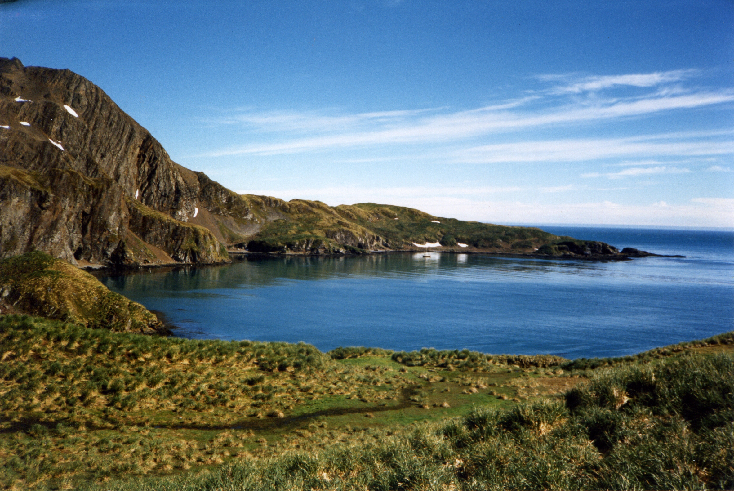
The old whaling station is situated in North Bay. To enter this, pass N of Brutus Island (Saddle Island on old charts) and thread your way through the kelp beds. There is really too much kelp in North Bay to consider anchoring. The wooden jetty is in a poor state, but is strong enough for a yacht to tie up to, with 7m of water alongside. There is no fendering on the dock and a fender board would be most useful. The decking on the jetty is very rotten and care should be taken when walking about on it.

If intending to stay for more than a brief visit, it may well be worth considering tying up bow and stern between the W end of the dock and a short wooden pier further W. Curlew tied up in this manner when visiting the harbour.

The whaling station was abandoned in 1946 and the buildings are in a poor condition, but there does not appear to have been as much vandalism here as at other sites. Consequently, the station is less depressing than most. 


PRINCE OLAV HARBOUR LOOKING SE


A wallow of elephant seals

The hulk of the Brutus is lying, half submerged, S of Pig Point. She was a three-masted, iron-hulled vessel, 76m long and 1686 tons. She was built in 1883 by J Reid and Co. of Glasgow and was first named Sierra Pedrosa while owned by the Sierra Shipping line of Lima. After coming to South Georgia, she was used as a coaling hulk alongside the jetty, before ending her days on the beach.


BAY OF ISLANDS


This is an aptly-named bay about 10 miles long and containing within its compass, a number of low, tussac-covered islands. Several of these are nesting sites for Wandering albatross and the big, white birds, dotting the islands, can easily be seen from quite some distance away.

It was around here that Robert Murphy, the naturalist on board the whaler, Daisy, spent much of his time when in South Georgia, which he recorded in A Logbook for Grace. He did the initial survey of the area, which was used until quite recently, and named many of the islands and other features.

BECKMANN FJORD (BAY OF ISLANDS)


54o03'S 37o11'W
Chart 3585, Cape Buller to Cape Constance


This fjord lies at the E end of the Bay of Islands and provides two anchorages. There is a long line of kelp extending from the E shore across the entrance; pass to the W of this. Various other patches of kelp have to be avoided once in the fjord. A drying rock lies about 200m off the small headland separating the SW and the SE extremities of the fjord.

The first anchorage is found in the W corner of the SE part of the bay, behind the small headland mentioned above. There are quite a few rocks close to the headland. Anchor clear of the kelp, near the beach, in 12m. This gives shelter from NW through W to S.

Off the beach, at the E side of the SE corner of Beckmann Fjord, we found 10.5m, clear of kelp. This anchorage would give shelter from N through E to S.

When visited, there was little swell, but this was probably the exception.

Beckmann Fjord may well give the best shelter from the E in the Bay of Islands.


BECKMANN FJORD, LOOKING S


Sunday, 16 February 2025

PRION ISLAND (BAY OF ISLANDS)

 
54o01'S 37o15'W
Chart 3585, Cape Buller to Cape Constance


A very small cove is situated at the SE corner of this island. Approach from the SE and work your way in through the kelp between the two rocks, as shown on the sketch chart. Once inside the kelp, there is a small basin, about 90m across, close to the beach.

Anchor in the centre in 2.4m, sand and a little weed. There is shelter from the NW.

This tiny anchorage is fine for a short stay in fair weather. Several Wandering albatross nest on the island.

It is possible to anchor outside the cove in 12m in a clear patch in the kelp. This is also sheltered from the NW.


PRION ISLAND, LOOKING S


ALBATROSS ISLAND (BAY OF ISLANDS)

 
54o01'S 37o20'W
Chart 3585, Cape Buller to Cape Constance


At the S end of this island, there is an anchorage off a shingle beach. This is the Miracle Cove mentioned in Gerry Clark's The TOTORORE Voyage. A reef extends SW from the S tip of the island, marked by thick kelp beds. Enter the cove from the SW, heading NE towards the beach, between the line of kelp and the kelp along the shoreline.

Anchor near the beach in 7m, clear of kelp. It is sheltered from the N through E to SE.

There are many Wandering albatross nesting on the higher ground and also some Giant petrels.


ALBATROSS ISLAND, LOOKING SW


SALISBURY PLAIN (BAY OF ISLANDS)

 
54o03'S 37o20'W
Chart 3585, Cape Buller to Cape Constance

The most outstanding feature of this area is the enormous King penguin colony that lies a little W of the Lucas Glacier. 


The best place from which to visit this rookery seems to be off the long beach, SSE of Tern Island. 


There are a couple of drying rocks close to the beach here and large beds of kelp. We found a small patch clear of kelp near the E end and anchored in 13.5m. It was found that there was shallower water further offshore in 10 to 11m, again in small areas, clear of kelp. There is shelter from the W and S.

The penguin colony can clearly be identified from the anchorage and it is an easy walk with relatively few fur seals about. Landing on the shingle beach may well be difficult if there is any swell.


SALISBURY PLAIN, LOOKING NW, BADGER ANCHORED IN THE CENTRE


JOCK COVE (BAY OF ISLANDS)

 
54o02'S 37o26'W
Chart 3585, Cape Buller to Cape Constance

On the N shore of Sunset Fjord, the headland of Jock Point forms a small Cove.

Anchorage can be obtained in 7m off the shingle beach clear of kelp and sheltered from SW through N to NE. Small quantities of ice from the Brunonia Glacier were in the Fjord, but there was no ice in Jock Cove, when visited. The Glacier is receding and now has only a small calving front.


JOCK COVE, LOOKING E